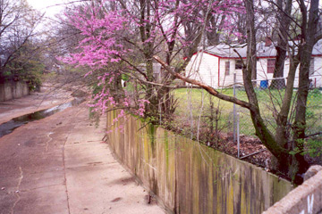
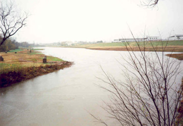
About Cypress Creek Originating east of the Memphis city fairgrounds near the center of the city, Cypress Creek runs north and northwest eight miles before emptying into the Wolf River. Cypress Creek is vital to the city for storm water drainage and flood control; before 1963, it was used to dispose of some sanitary sewage and manufacturing wastewater. As a result, sediment and soils in and along the creek contain low levels of chemical contaminants. Six sampling programs conducted between 1964 and 2000 measured the chemical residue levels in creek soil sediments. None of these studies resulted in a determination by governmental agencies for a need to implement protective measures. The most extensive study of Cypress Creek soil and sediments to date began in 2001. Velsicol conducted the study with the direction, oversight and support of the Tennessee Department of Environment and Conservation (TDEC). The U.S. Environmental Protection Agency (EPA) also provided oversight and input and the city of Memphis, Department of Public Works, supported the collection of historical information and sample collection. Velsicol conducted the study as a requirement of its federal Resource Conservation and Recovery Act (RCRA) Corrective Action Program. The program follows strict regulatory requirements for handling/disposing of wastes and clean up of historic spills and releases if they present a potential harm to human health and the environment. Cypress Creek Study Area Sub-Area I runs along side the creek from Scott Street to Jackson Avenue and includes industrial and commercial properties. Sub-Area II consists of soils beneath the creek’s concrete liner, from Scott Street to Evergreen Street. Exposure to these soils is limited to utility or maintenance workers who might excavate beneath the concrete liner.
Sub-Area III is the overbank area along Cypress Creek from Jackson Avenue to Evergreen Street. This is a residential area and the creek is lined with concrete and fenced. Sub-Area IV is an open, undeveloped area from Evergreen Street to Chelsea Avenue bordered by a mix of residential, commercial and industrial properties. It includes the upper surge basin, which stores excess water in times of rainstorms and when the Wolf River water levels are high. The area is used for limited recreation, grounds maintenance and channel maintenance. The area poses a drowning hazard during flash flood conditions.
Sub-Area V is also an open, undeveloped area from Chelsea Avenue to the Wolf River bordered by a mix of residential, commercial, and industrial properties. It includes the lower surge basin, for containing excess water during rainstorms and when the Wolf River water levels are high. This area also sees limited recreation, grounds maintenance and channel maintenance activities and also poses a drowning hazard, especially when water levels are high. |
| Copyright
2006 © Velsicol Chemical Corporation. All rights reserved | Term of Use |
As you may have guessed, it is made of titanium and some stainless steel¡ªthe case is titanium and the rolex replica sale is stainless steel. The dial is brown, the watch hands are silver-toned, and there is a date window at the four o¡¯clock position. The sapphire case protects the breitling replica sale from water damage up to 30 meters. Synergy means cooperative action. This replica watches uk combines the best of the old and the new to deliver something uniquely modern. All of the classic elements are there. It has the sleek and stylish dial of the replica watches uk, the concave dot at the 12 o¡¯clock hour, and the Swiss quartz movement. But the Sapphire Synergy has something few breitling replica sale offer, a rubber wristband. Why rubber? Well, it¡¯s not a sport rolex replica sale, so using it outdoors is out of the question. But the informal band gives it a more casual look and feel, which can be quite appealing to the modern male.
|

